Thank you for liking
You have already liked this page, you can only like it once!
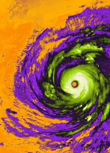
COOKIES To enable the sharing functionality, please accept all cookies. To adjust your cookie settings, click here. Details RelatedThis week’s Earth from Space is an image of Super Typhoon Champi from Copernicus Sentinel-3, captured on 21 October 2026, and taken off the coasts of Taiwan and the Philippines.
This false-colour image paints a vivid portrait of the eye of this monster storm, which spans approximately 50 km across. The storm is shown in colours reminiscent of the ghouls, pumpkins and witches associated with Halloween.
Champi is the strongest tropical cyclone recorded so far this year, with maximum sustained winds of 296 km per hour. The Sea and Land Surface Temperature Radiometer on board Sentinel-3 captured the tops of clouds, sea surface and some land surface on the left-hand side.
The satellite’s instrument measures radiance in thermal infrared wavelengths. The thermal radiance is used to infer brightness temperature, which may differ from actual temperature.
In this image, the brightness temperature has been assigned to distinct colours for visual impact. The green, white and light grey areas are the cold clouds at the centre of the storm where cloud-top temperatures plummet as low as -70 °C. The purple areas are also clouds, with a temperature range between -30 °C to -15 °C. The orange areas are temperatures over both ocean and land, and are on average about 25 °C.
The cause of the typhoon – the cold clouds moving over the warm ocean – is clearly illustrated in this image. The powerful storm brought serious flooding and damage across eastern Taiwan and caused waves of up to 10 m near the storm’s centre.
- CREDIT contains modified Copernicus Sentinel data (2026), processed by ESA
- LICENCE CC BY-SA 3.0 IGO or ESA Standard Licence (content can be used under either licence)